Summary of the materials
Borstein Enterprises is proposing Topanga Grounds, a for-sale condominium community in Canoga Park. The October 15, 2026 City Planning application describes 269 homes, including 13 very-low-income homes, replacing a commercial nursery, church, accessory parking and four existing dwellings. The proposal includes detached homes and attached duplex structures, two to three stories tall, with a maximum height of 38 feet.
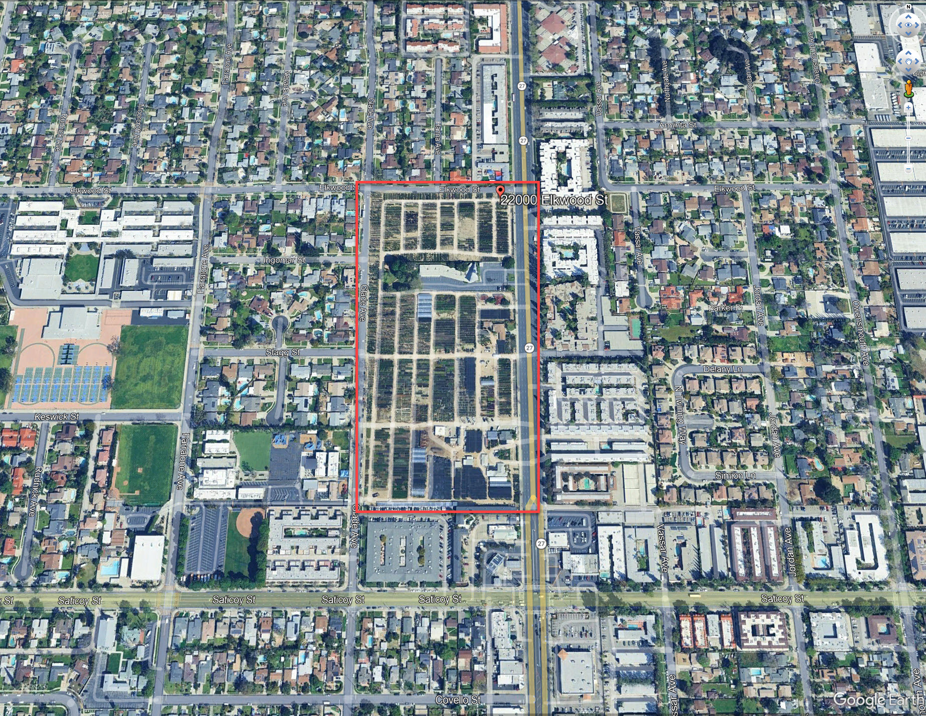
The site includes 7639–7827 N. Topanga Canyon Boulevard, 7716 and 7746 N. Glade Avenue, and 22000 W. Elkwood Street. The supplied aerial shows the nursery property between Topanga Canyon Boulevard and Glade Avenue, south of Elkwood Street and north of Saticoy Street. The tract map and environmental form identify approximately 20.05 gross acres.
The requested approvals include Density Bonus Compliance Review, Project Review and a Vesting Tentative Tract Map. The applicant requests an AB 130 statutory CEQA exemption. The supplied materials describe an application and supporting arguments; they do not establish final City approval.
City Planning application
The application identifies case CPC-2026-5371-DB-PR-VHCA, environmental case ENV-2026-5379-EAF and related tract VTT-85385. It proposes individual condominium ownership for 269 homes: 256 market-rate and 13 very-low-income units. It lists 725,675 square feet of new construction, demolition, grading, tree removal and public-right-of-way dedications along Topanga Canyon Boulevard, Elkwood Street and Glade Avenue. Existing zoning is A1-1 and RA-1, with Low Residential and Low Medium II Residential land-use designations.
Vesting Tentative Tract Map
The uploaded drawing is titled Vesting Tentative Tract Map No. 85385, prepared for Borstein Enterprises for condominium purposes and dated October 2, 2026. It shows the proposed layout, private drives, conceptual building footprints, street sections, easements and detached, duplex and cluster configurations. Its notes describe one master ground lot and 270 residential condominiums, a count that differs from the application. The drawing is labeled sheet 1 of 6; only that sheet is included in the supplied PDF.
Findings and preliminary application letter
The file labeled “Findings” contains a September 11, 2026 letter from the applicant’s land-use counsel, an AB 130 eligibility analysis and screening maps. It describes an earlier 271-unit proposal and a 253-unit base density. The letter states that 13 very-low-income units support a 20% density bonus and eligibility for up to 304 units. It requests an incentive concerning affordable-unit distribution and waivers for averaging across zones, setbacks, building separation, height and floor area. It asserts SB 330 vesting and requests commencement of tribal consultation. These are the applicant’s positions, rather than adopted City findings.
Environmental Assessment Form
The form describes 269 for-sale homes: 167 single-family dwellings and 102 duplex dwelling units. It identifies four existing homes for demolition, a maximum of three stories and 38 feet, and a requested AB 130 exemption under Public Resources Code Section 21080.66. It records nearby residential uses and Faith Baptist School, tree information, grading questions and transportation screening. Some quantities remain to be determined; the transportation assessment is marked not completed. This is an applicant-submitted intake form, rather than a completed environmental impact report or final exemption determination.
Aerial context
The red-outlined aerial shows the nursery site and its relationship to nearby homes, school grounds and surrounding streets. It provides context rather than a substitute for surveyed legal boundaries.
Differences to reconcile
- Homes: 271 in the September letter, 270 residential condominiums in the tract-map notes, and 269 in the October application and environmental form.
- Floor area: the environmental narrative gives 648,344 square feet and a 0.84:1 FAR, while its project-size table and the application list 725,675 square feet.
- Site area: the environmental form pairs 771,306 net square feet with 17.03 acres, figures that do not agree mathematically. The preliminary letter describes approximately 17.7 acres; the map and environmental form list approximately 20.05 gross acres.
These differences should be reconciled against the current plan set and City case record before relying on a single development program. No final approval or current hearing status is established by this summary. The City case page could not be retrieved during review.
View the Los Angeles City Planning case record ↗
Source materials reviewed: City Planning application (project description and housing information); Vesting Tentative Tract Map No. 85385, sheet 1; September 11, 2026 preliminary application letter and supporting exhibits; Environmental Assessment Form; and supplied aerial photograph.